In early July my family traveled to Bar Harbor for four nights at the Bar Harbor Inn. We figured that we'd pretty much experience everything we wanted to during our four nights and five days, but it didn't take long to discover that we needed at least a couple more days.
 |
| The family at Intersection 7. |
Eagle Lake Loop
During our stay in Bar Harbor, I took three different bike rides on the trails. The first ride was with my family. We started at the Eagle Lake parking lot on Route 232. It was a cool morning and there was an ever so slight sprinkle in the air, so I think that kept some people in their hotels.
 | |
| On the shore of Eagle Lake |
From here we kept left at the intersection and headed down a long hill. The biggest challenge on this hill was keeping Ashton in sight as he cruised down the hill, presumably without ever squeezing his brakes.
At Intersection 7, we took a short break and wandered down to the lake shore. The thing to remember about the lakes is that many of them are fresh water supplies for the residents of Mt. Desert Island, so please refrain from taking a dip. After all, you're on the largest island off the coast of Maine and one of the largest islands on the East Coast with salt water all around, so where else would the residents and visitors get water to drink?
 |
| Bethany and Steve enjoying the view of Eagle Lake |
The east side of the lake was pretty flat with the exception of a couple minor undulations, but again, it made for a nice leisurely ride back to the parking lot.
Hadlock Pond Loop
 |
| Hemlock Bridge |
This started out on a pretty flat road for about mile to the Hadlock Brook Bridge, a small stone bridge crossing Hadlock Brook. Then there was a pretty steady uphill climb to Intersection 12 where I got a view back towards Upper Hadlock Pond. From here it was a pretty flat ride over to the Hemlock Bridge and Waterfall Bridge.
 |
| Waterfall Bridge |
After climbing around the ravines beneath the bridges, I hopped back on my bike and continued along the road. From the Waterfall Bridge back to the parking lot was an easy coast down a long hill. I'm not sure I had to pedal at all until I got back to Intersection 18 and headed back to the car.
The last loop was the Witch Hole Pond Loop which I accessed from the north end of the Visitor Center Parking Lot. You can also get to this loop from Duck Brook Road, or if you wanted to add an extra two miles, from the Eagle Lake Parking Lot.
This one had a lot more ups and downs. The first up, was probably the steepest climb of all the trail I rode. If this was your first experience on the trails, I could see where it might be discouraging because the climb from the parking lot to the loop was about a half mile uphill. Once you got to Intersection 1, it wasn't so bad. The road meandered past Witch Hole Pond and a couple other ponds before getting to Intersection 4. Just for kicks, I rode this 1.1 mile trail over to the Eagle Lake Parking Lot, then turned around and headed back to the Witch Hole Loop.
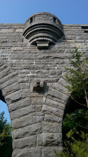
About half way through the ride, I came to the Duck Brook Bridge, which appeared to be the biggest one I'd seen. On the way back from Duck Brook Bridge, there were a couple areas where I could see Frenchman's Bay through the trees, but for the most part I was riding in the woods. All in all this was about a 7 mile outing.
 |
| Pond on Witch Hole Loop |
 |
| Looking up at Duck Brook Bridge |
 |
| Duck Brook Bridge |
 |
| Another pond view |
More random photos below.
 |
| Gatehouse Near Hadlock Loop |
 |
| Waterfall Bridge Selfie |
 |
| Not quite a fiddlehead |
 |
| View of Upper Hadlock Pond |

No comments:
Post a Comment